Posts

China Border with Pakistan

Image
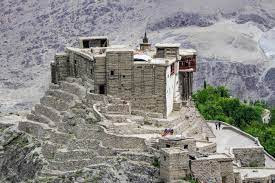
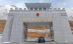
  The Pakistan-China border, also known as the Pak-China border, is a significant international boundary that separates the Islamic Republic of Pakistan and the People's Republic of China. This border is a crucial geopolitical feature, as it connects South Asia and East Asia while spanning various terrains, cultures, and historical ties. The border's length, which is of great strategic importance to both countries, has implications for economic, political, and security matters in the region. Length and Geography: The Pakistan-China border stretches for approximately 523 kilometers (325 miles) along the Karakoram mountain range in the northern part of the Indian subcontinent. It begins at the trijunction point where the borders of China, Pakistan, and India meet and extends to the eastern end of the Wakhan Corridor in Afghanistan. The Karakoram range is known for its towering peaks, including the world's second-highest peak, K2. Historical Context: The historical connection

Baltit Fort is a historic fortification

Image
  Baltit Fort is a historic fortification located in the town of Karimabad in the Hunza valley of the Gilgit-Baltistan region in Pakistan. It is one of the oldest and most significant landmarks of the region and has played an important role in the region's history and culture. The fort is believed to have been built around 700 years ago, during the time of the Ayasho dynasty. At the time, it was a small watchtower that was used as a lookout point by the local villagers to keep an eye on the surrounding area. Over the centuries, the fort was gradually expanded and fortified by the Mirs (rulers) of Hunza. The fort's strategic location made it an important military stronghold, and it was the site of many battles and conflicts in the region. The Mirs of Hunza used the fort as their seat of power, and it was also a center of trade and commerce, as it was located on the ancient Silk Road. In the 16th century, the fort was further enlarged and fortified by the Mirs of Hunza. They adde

Karakoram Highway [Eighth wonder of the world]

Image
  The Karakoram Highway is one of the highest and most challenging roads in the world. It spans over 1,200 km (746 miles) from Abbottabad in Pakistan to Kashgar in China, crossing the Karakoram mountain range at an altitude of over 4,600 meters (15,000 feet). It is also known as the KKH, and it is considered one of the engineering wonders of the world. The highway was built in the 1960s and 1970s by the governments of Pakistan and China. It was designed to facilitate trade and communication between the two countries and to provide a strategic link between Central Asia and South Asia. The construction of the road was a huge feat of engineering, as it had to cross some of the highest mountain ranges in the world, including the Himalayas, Karakoram, and Pamir. The Karakoram Highway offers some of the most breathtaking scenery in the world. The road runs through some of the most remote and rugged terrain on the planet, passing through deep valleys, over high passes, and alongside towering

Is hunza better or skardu?

Image
  Hunza and Skardu are both located in the Gilgit-Baltistan region of Pakistan and are known for their natural beauty and unique cultural heritage. However, each destination offers different experiences and attractions, making it difficult to say which is "better." Hunza is a valley known for its stunning landscapes, including terraced fields, apple orchards, and towering peaks. It is also known for its rich cultural heritage, with a distinct way of life, architecture, and traditions. Visitors to Hunza can explore local villages, visit historic sites, and enjoy the peace and tranquility of the valley. Skardu, on the other hand, is a city that is a hub for adventure sports and outdoor activities. It is surrounded by some of the highest peaks in the world, including K2, and is a popular starting point for trekking and mountaineering expeditions. Skardu also has its own unique cultural heritage, with a rich history and unique architecture. Visitors to Skardu can enjoy adventure

Shigar Valley Skardu

Image
  Shigar Valley is a picturesque region located in the northern areas of Pakistan, in the Gilgit-Baltistan province. This valley is known for its stunning beauty, unique culture, and rich history. With its breathtaking views, lush green forests, and high peaks, Shigar Valley is a popular destination for tourists, trekkers, and mountaineers. The valley is located on the Indus River, surrounded by towering mountains, which provide a stunning backdrop to the fertile landscape. Shigar Valley is known for its fertile soil, which supports a diverse range of crops, including apples, pears, apricots, and walnuts. The valley is also home to many different species of wildlife, including snow leopards, ibex, and markhors. The people of Shigar Valley are friendly and welcoming, and they are proud of their rich cultural heritage. They have a unique and distinctive style of architecture, which reflects their nomadic past. Many of the houses in the valley are made of stone and wood, and they have fla

Top 5 most visited travel destinations in Pakistan

Image
Yes, those are all beautiful tourist destinations in Pakistan. The Neelum Valley is known for its lush green scenery and crystal-clear rivers. The Nagar Valley is famous for its stunning mountain views, including the famous peak Ultar Sar. The Swat Valley is known for its beautiful landscapes, ancient Buddhist heritage, and the famous Malam Jabba Ski Resort. Skardu is a popular destination for trekking and mountaineering, and it is also home to the famous Shigar Fort. These are the 5 most beautiful places in Pakistan  1. Naran Kaghan   Naran Kaghan is a beautiful tourist destination located in the Khyber Pakhtunkhwa province of Pakistan. It is situated in the Mansehra district and is known for its picturesque landscapes, lush green valleys, and snow-capped mountains. The Naran Kaghan Valley is a popular destination for trekking, hiking, and camping. Visitors can also enjoy fishing, river rafting, and paragliding in the area. Some of the popular tourist spots in Naran Kaghan include Lak

The Khunjerab Pass-Gilgit Baltistan

Image
The Khunjerab Pass is a high mountain pass that connects Pakistan and China through the Karakoram mountain range. The pass is located at an elevation of about 4,693 meters (15,397 feet) and is the highest paved international border crossing in the world. The pass is located in the Gilgit-Baltistan region of Pakistan and is a popular destination for trekkers and mountaineers. The road that leads to the Khunjerab Pass is also known as the Karakoram Highway and is considered one of the most scenic and treacherous roads in the world. The journey to the pass is only possible during the summer months and is closed during the winter due to heavy snowfall. Visitors to the Khunjerab Pass can enjoy panoramic views of the surrounding mountains and glaciers, as well as the opportunity to visit the nearby Sust village, which is the last Pakistani settlement before the border with China. It's an international Border crossing point between Pakistan and China and also connects the two countries vi